National Weather Service Miami South Florida Rain Chances
MIAMI, FL — The National Weather Service in Miami has issued a forecast of scattered showers and thunderstorms across South Florida today, Sunday, August 17, 2025, with chances favoring the interior and western areas amid a rare heatwave.
A few storms may become strong this afternoon, capable of producing damaging winds and heavy downpours. Excessive rainfall could lead to localized urban and poor drainage flooding.
Temperatures will reach the low 90s, with high humidity amplifying heat indices to 103-106°F.
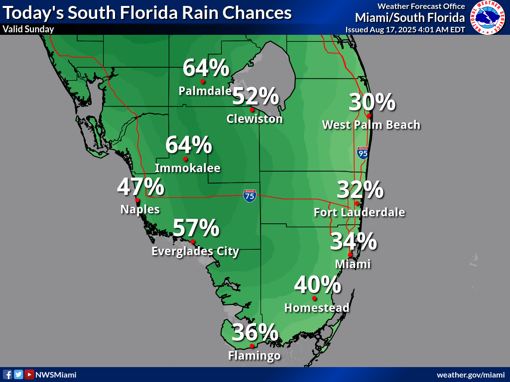
Rainfall chances today are moderate, with Palmdale at 64%, Clewiston at 52%, Immokalee at 64%, Naples at 47%, Everglades City at 57%, Miami at 34%, Fort Lauderdale at 32%, West Palm Beach at 30%, Homestead at 40%, and Flamingo at 36%, according to the NWS forecast. These probabilities show scattered shower and thunderstorm activity favoring the western half of South Florida, with potential for localized heavy rainfall.
Storm Timing:
Possible Hazards:
National Weather Service Miami South Florida Doppler Radar
Today
A chance of showers and thunderstorms after 2pm. Mostly sunny, with a high near 92°F. Heat index values as high as 103°F. Southeast wind 6 to 10 mph. Chance of precipitation is 30%. New rainfall amounts between a tenth and quarter of an inch possible.
Tonight
A chance of showers and thunderstorms before 2am. Partly cloudy, with a low around 81°F. East wind around 6 mph. Chance of precipitation is 30%.
Monday
A 40 percent chance of showers and thunderstorms. Mostly sunny, with a high near 91°F. Southeast wind around 8 mph.
Monday Night
A 20 percent chance of showers and thunderstorms. Partly cloudy, with a low around 81°F. East wind around 6 mph.
Tuesday
A 30 percent chance of showers and thunderstorms. Mostly sunny, with a high near 91°F. Southeast wind 7 to 9 mph.
Tuesday Night
A 20 percent chance of showers and thunderstorms. Partly cloudy, with a low around 80°F. East wind around 7 mph.
Copyright 2023-2025 FloridaWord.com


