NOAA National Hurricane Center Tropical Weather Outlook for August 11, 2025.
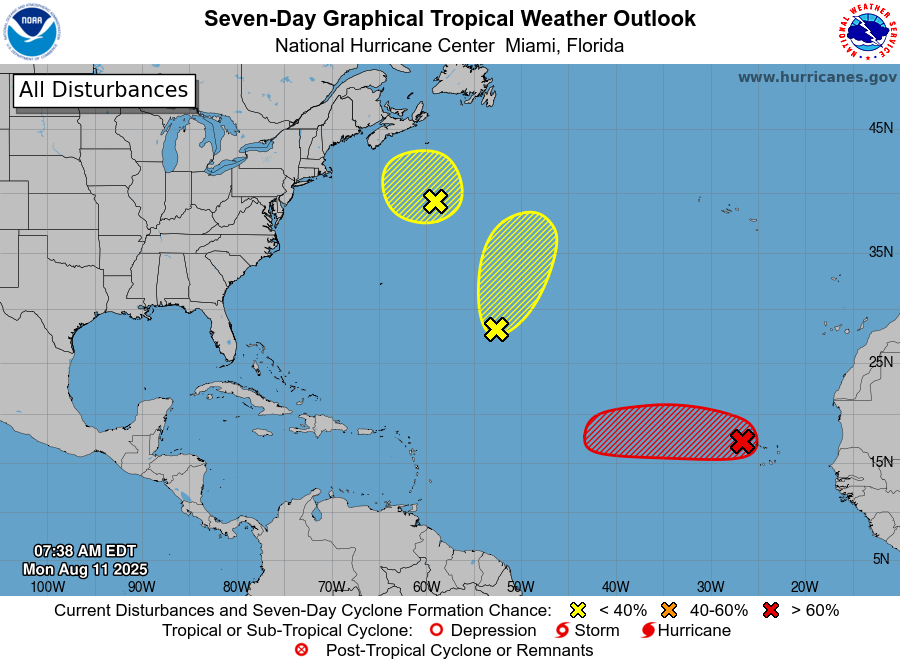
MIAMI, Florida – NOAA‘s National Hurricane Center in Miami, Florida, issued a Tropical Weather Outlook at 8 a.m. Eastern Daylight Time on Monday, August 11, 2025, due to the presence of Invest 97L located off the coast of Africa.
If Invest 97L develops into a tropical storm or hurricane, the next name on the 2025 Atlantic Hurricane List is Erin.
Shower and thunderstorm activity has persisted and continues to show signs of organization with a well-defined area of low pressure located just to the west of the Cabo Verde Islands (marked with a red “X”).
NHC forecasters say that If these structural trends continue, the system is likely to become a tropical depression or storm, possibly as soon as later this morning. Locally heavy rainfall and gusty winds are expected to continue today across portions of the Cabo Verde Islands, and interests there should monitor the progress of this system.
Regardless of development over the next couple of days, the system is expected to continue moving westward to west-northwestward at 15 to 20 mph across the eastern and central tropical Atlantic.
This system has an 90% chance of tropical cyclone formation within the next 7 days and a 90% chance within the next 48 hours.
Computer models, often referred to as spaghetti models, are in general agreement during the first 72 hours that the system will move in a west-northwestward direction over the open tropical Atlantic.
NOAA forecasts an “above-normal” 2025 Atlantic Hurricane Season, which runs from June 1 through November 30.
Although peak hurricane season isn’t until September 10, hurricane and tropical storm activity begins to pick up in August according to NOAA and the National Weather Service‘s historical hurricane activity data.
Copyright 2023-2025 FloridaWord.com


