NOAA National Hurricane Center Tropical Weather Outlook for August 5, 2025.
MIAMI, Florida – NOAA‘s National Hurricane Center in Miami, Florida, issued a Tropical Weather Outlook at 8 AM Eastern Daylight Time on Tuesday, August 5, 2025, monitoring systems in the Atlantic including one that may develop off the coast of Florida.
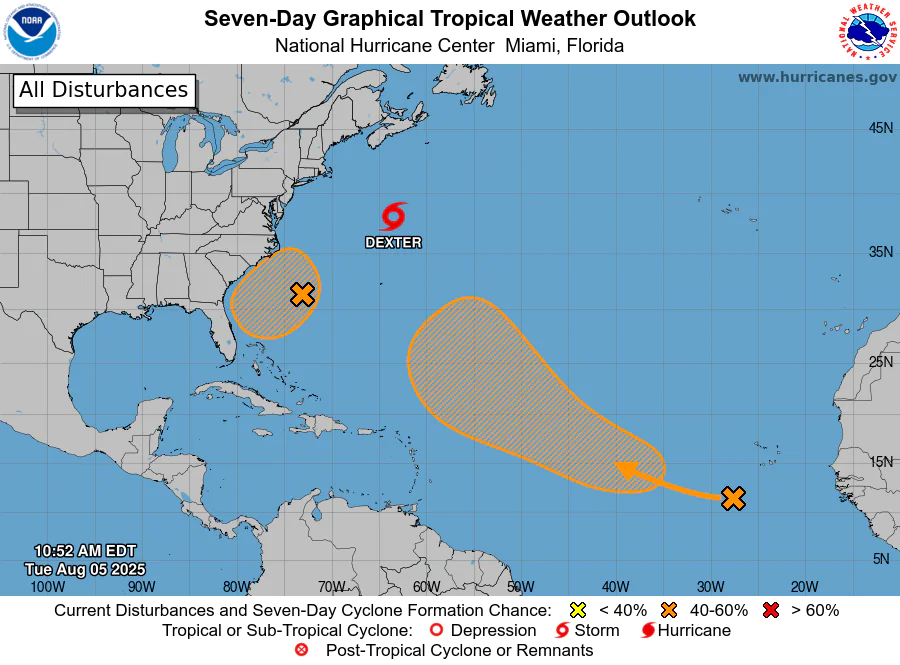
The system (marked with an orange shaded area near Florida) is a weak surface trough located several hundred miles off the coast of the southeastern United States that is producing scattered showers and thunderstorms.
This system is expected to form an area of low pressure in a day or so, and then move slowly westward initially, but turn more northward by this weekend.
NHC forecasters say that environmental conditions appear favorable for gradual development of this system, and a tropical depression could form by the latter portion of this week or over the weekend as the low moves across the western Atlantic.
This system has a 40% chance of tropical cyclone formation within the next 7 days and a 10% chance within the next 48 hours.
If this system develops into a tropical storm or hurricane, the next name on the 2025 Atlantic Hurricane List is Erin.
In addition to this system, the NHC is issuing advisories on Tropical Storm Dexter, located over the northwestern Atlantic Ocean off North Carolina, and monitoring another tropical wave over the far eastern tropical Atlantic with a 50% chance of formation over 7 days.
NOAA forecasts an “above-normal” 2025 Atlantic Hurricane Season, which runs from June 1 through November 30.
Although peak hurricane season isn’t until September 10, hurricane and tropical storm activity begins to pick up in August, according to NOAA and the National Weather Service‘s historical hurricane activity data.
Copyright 2023-2025 FloridaWord.com

