National Weather Service Jacksonville North Florida Rain Chances and Temperature forecast.
JACKSONVILLE, Florida – The National Weather Service in Jacksonville has issued a forecast for North Florida predicting heavy rainfall with a risk of flash flooding on Sunday, August 10, 2025, with continued risks through Monday.
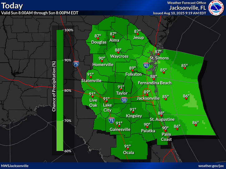
According to NWS Jacksonville, continued daily rounds of heavy rainfall on saturated ground will bring a localized flood risk through Monday, especially across coastal southeast Georgia.
Morning and early afternoon storms near the Atlantic coast will shift inland into the afternoon and early evening. Heavy downpours are expected, with periods of heavy rainfall bringing isolated flood risk through the weekend.
Storms will be capable of producing:
The greatest flood risk is in coastal southwest Georgia, with expected rainfall of 1-2 inches and locally as high as 3-4 inches. There is also a high chance of precipitation, ranging from 80-100% across much of the region from 8:00 AM to 8:00 PM EDT.
North Florida cities at risk for heavy rainfall and flash flooding include regions within the shaded area such as:
Additionally, heavy downpours on already-saturated ground increases the risk for flooding, especially in urban, low-lying, saturated, and poor drainage areas. Avoid flooded areas and never enter flood waters.
Today (Sunday)
A chance of showers and thunderstorms, then showers and possibly a thunderstorm after 2pm. High near 89. Southeast wind 6 to 10 mph, with gusts as high as 15 mph. Chance of precipitation is 80%. New rainfall amounts between a tenth and quarter of an inch, except higher amounts possible in thunderstorms.
Tonight
Showers and thunderstorms likely before 11pm, then a chance of showers. Mostly cloudy, with a low around 76. Southeast wind 6 to 9 mph, with gusts as high as 15 mph. Chance of precipitation is 60%. New precipitation amounts between a tenth and quarter of an inch, except higher amounts possible in thunderstorms.
Monday
A chance of showers and thunderstorms, then showers and possibly a thunderstorm after 2pm. High near 91. Heat index values as high as 105. Southeast wind 6 to 10 mph, with gusts as high as 16 mph. Chance of precipitation is 80%. New rainfall amounts between a tenth and quarter of an inch, except higher amounts possible in thunderstorms.
Monday Night
Showers and possibly a thunderstorm before 8pm, then a chance of showers and thunderstorms between 8pm and 2am. Low around 77. Southeast wind 5 to 9 mph becoming light after midnight. Chance of precipitation is 80%.
Copyright 2023-2025 FloridaWord.com


