National Weather Service Tallahassee rain chances for the Florida Panhandle and Big Bend
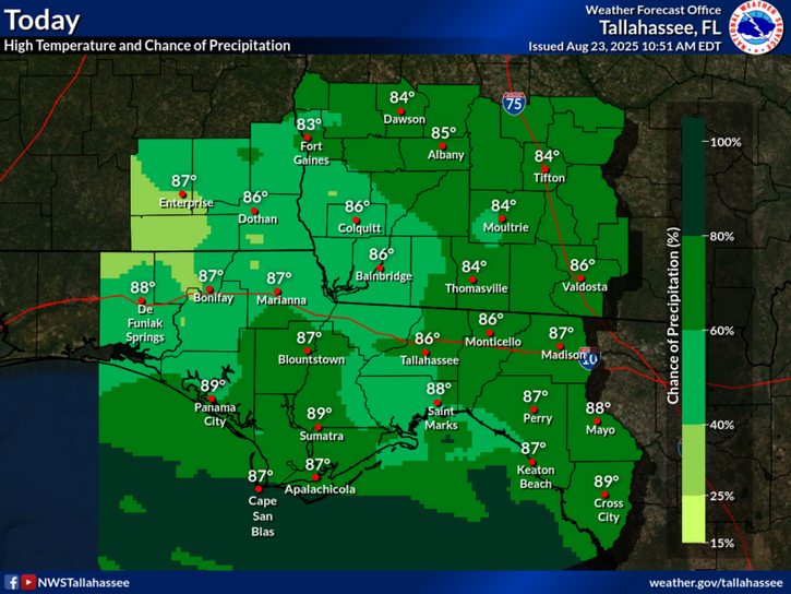
TALLAHASSEE, Florida – The National Weather Service Tallahassee forecasts showers and thunderstorms for the Florida Big Bend and far south Georgia on Saturday, August 23, 2025. A stalled front will bring numerous showers and storms, with locally heavy rain possible anywhere, but the heaviest rain and greater chance for flash flooding across southwest Georgia this afternoon and evening.
Meteorologists anticipate rainfall amounts ranging from a quarter to a half of an inch, with higher amounts possible in thunderstorms. In southwest Georgia, under a Level 2 Slight Risk of excessive rainfall, 1-3 inches are expected, with isolated 4-6 inches possible, leading to potential flash flooding.
A concurrent Flood Watch warns of flash flooding risks, particularly in areas like Albany and Tifton, where slow-moving storms could exacerbate runoff.
Showers and thunderstorms are expected mainly after 2pm today, with high chances continuing through the weekend.
While heavy rain may be isolated in some areas, be prepared to head indoors when storms approach due to lightning risks and potential flooding.
Temperatures today will reach near 86°F, with similar conditions expected through the weekend, closer to the mid-80s, due to persistent cloud cover and showers.
Today
Showers and thunderstorms, mainly after 2pm. Patchy fog before 9am. High near 86. Calm wind becoming southwest around 5 mph. Chance of precipitation is 90%. New rainfall amounts between a quarter and half of an inch possible.
Tonight
Showers and thunderstorms, mainly before 8pm. Low around 73. Calm wind. Chance of precipitation is 80%.
Sunday
A chance of showers, then showers and thunderstorms likely after 11am. Partly sunny, with a high near 87. Calm wind becoming west around 5 mph in the afternoon. Chance of precipitation is 70%.
Copyright 2023-2025 FloridaWord.com


