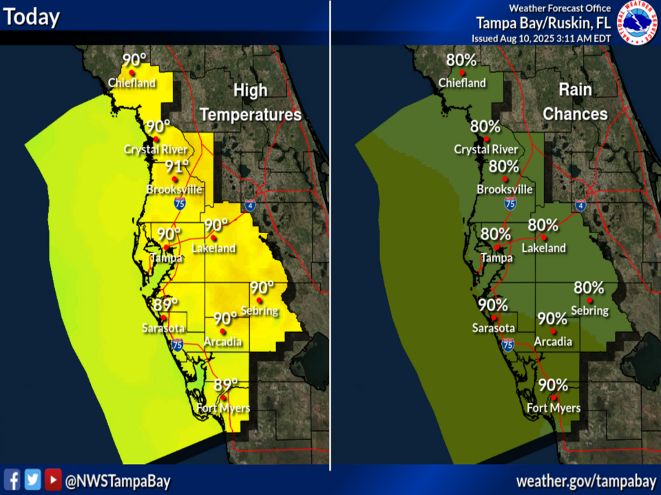
National Weather Service Tampa Bay rain chances and high temperatures.
TAMPA BAY, Florida – The National Weather Service Weather Prediction Center has issued an Excessive Rainfall Outlook for Central Florida on Sunday, August 10, 2025, indicating a marginal risk of excessive rainfall this afternoon and evening.
Scattered thunderstorms are anticipated across the Florida Peninsula, influenced by a weak low/mid-level trough off the Atlantic Coast and an area of low pressure offshore the east coast of Florida producing disorganized showers.
Heavy rainfall could lead to localized flash flooding over portions of Florida through mid-week.
The National Weather Service (NWS) Tampa Bay has issued an excessive rainfall outlook for Sunday, August 10, 2025, warning of a Level 1 out of 4 risk for excessive rainfall across the Florida Peninsula, including west central and southwest Florida.
The potential hazards include ponding of water in urban areas or locations with poor drainage, frequent lightning, and isolated damaging wind gusts.
The forecast covers areas such as Tampa, St. Petersburg, Sarasota, and Fort Myers.
The storms will develop along the Atlantic Coast and spread inland across the Florida Peninsula this afternoon and evening.
Today
A chance of showers and thunderstorms, then showers and possibly a thunderstorm after 2pm. High near 90. Heat index values as high as 101. South wind 6 to 9 mph. Chance of precipitation is 80%. New rainfall amounts between a tenth and quarter of an inch possible, except higher amounts possible in thunderstorms.
Tonight
Showers and thunderstorms, mainly before 2am. Low around 76. Southeast wind around 6 mph. Chance of precipitation is 80%. New rainfall amounts between a tenth and quarter of an inch possible, except higher amounts possible in thunderstorms.
Monday
A chance of showers and thunderstorms, then showers likely and possibly a thunderstorm after 2pm. Mostly sunny. High near 94. Heat index values as high as 105. Southeast wind 6 to 8 mph. Chance of precipitation is 70%. New rainfall amounts between a tenth and quarter of an inch possible, except higher amounts possible in thunderstorms.
Monday Night
Showers likely and possibly a thunderstorm before 8pm, then a chance of showers and thunderstorms between 8pm and 2am. Partly cloudy. Low around 78. South southwest wind around 5 mph becoming light and variable in the evening. Chance of precipitation is 60%.
Copyright 2023-2025 FloridaWord.com


