NOAA National Hurricane Center Tropical Storm Chantal 2025 Projected Path
CHARLESTON, South Carolina – NOAA‘s National Hurricane Center issued a Public Advisory at 8 a.m. Eastern Daylight Time on Saturday, July 5, 2025, as Tropical Depression Three has strengthened into Tropical Storm Chantal.
A Tropical Storm Warning is in effect from South Santee River, South Carolina to Cape Fear, North Carolina.
A Tropical Storm Warning means that tropical storm conditions are expected within the warning area, generally within the next 12 to 24 hours.
A Tropical Storm Watch is in effect from Edisto Beach to South Santee River, South Carolina.
A Tropical Storm Watch means that tropical storm conditions are possible within the watch area, generally within the next 12 hours.
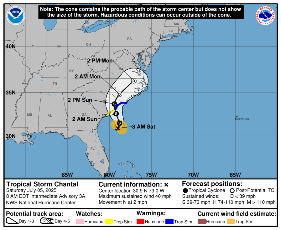
Tropical Storm Chantal (formerly Invest 92L and Tropical Depression Three) is located near latitude 30.9 North, longitude 79.0 West, about 150 miles south-southeast of Charleston, South Carolina, and 240 miles south-southwest of Wilmington, North Carolina, moving north at 2 mph (4 km/h).
NHC forecasters expect a slow motion toward the north-northwest to begin later today, followed by a turn to the northeast by Sunday night. On the forecast track, the center of Chantal is expected to move across the coast of South Carolina Sunday morning.
Computer models, often referred to as spaghetti models, show Tropical Storm Chantal moving north-northwest toward South Carolina, with a turn to the northeast by Sunday night.
The NHC track forecast has been shifted eastward, favoring the deterministic ECMWF (EMXI) European model over the GFS (AVNI) American model, though it remains west of some track aids, reflecting a spread in forecast direction and speed.
Tropical Storm Chantal has maximum sustained winds of 40 mph (65 km/h) with higher gusts, and tropical-storm-force winds extend up to 70 miles (115 km) primarily to the east of the center. The minimum central pressure is 1009 mb (29.80 inches).
Some additional strengthening is expected before Chantal reaches the South Carolina coast on Sunday morning.
Tropical storm conditions are expected in the warning area beginning this evening and continuing into Sunday morning, with possible conditions in the watch area starting later today.
Chantal is expected to produce heavy rainfall of 2 to 4 inches, with local amounts up to 6 inches, across the coastal plain of the Carolinas through Monday, increasing the risk of flash flooding.
Storm surge may cause flooding with water heights of 1-3 feet from South Santee River, SC to Cape Fear, NC, and 1-2 feet from Edisto Beach to South Santee River, SC, if peak surge coincides with high tide.
Life-threatening surf and rip currents are expected along the coast from northeastern Florida to the Mid-Atlantic states over the next couple of days.
NOAA forecasts an “above-normal” 2025 Atlantic Hurricane Season, running from June 1 through November 30. Although the peak is September 10, tropical storm activity increases in early July, per NOAA and NWS historical data.
Copyright 2023-2025 FloridaWord.com


