
JACKSONVILLE, Florida – The National Weather Service Storm Prediction Center has issued a severe weather outlook for North Florida, with a risk of strong thunderstorms across the region on Wednesday, June 11, 2025.

According to NWS Jacksonville, strong to severe thunderstorms are expected this afternoon and evening, with the highest risk inland between I-95 and I-75, including parts of northeast Florida and southeast Georgia, where sea breeze boundaries enhance storm potential.
Stronger storms will be capable of producing:
- Damaging winds (up to 40-55 mph), capable of impacting structures and trees.
- Heavy downpours, which may lead to localized flooding, with rainfall totals forecasted up to 1 inch in some areas, posing a flash flood risk.
- Frequent lightning strikes, posing a fatal risk to people and pets outdoors.
North Florida cities at risk for strong thunderstorms include:
- Jacksonville
- Palatka
- Lake City
- Gainesville
- Ocala

Jacksonville Weather Forecast
This Afternoon
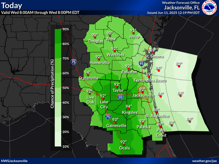
Showers and thunderstorms likely, mainly after 2 PM. Mostly sunny, with a high near 92. Heat index values as high as 102. Southeast wind around 9 mph. Chance of precipitation is 60%. New rainfall amounts between a tenth and quarter of an inch, except higher amounts possible in thunderstorms.
Tonight
Showers and thunderstorms likely before 10 PM, then a slight chance of showers between 10 PM and 11 PM. Mostly cloudy, with a low around 75. South wind 5 to 10 mph, with gusts as high as 16 mph. Chance of precipitation is 60%. New precipitation amounts of less than a tenth of an inch, except higher amounts possible in thunderstorms.
Thursday
A slight chance of showers before 11 AM, then a slight chance of showers and thunderstorms between 11 AM and 2 PM, then showers and possibly a thunderstorm after 2 PM. High near 91. Heat index values as high as 102. South wind 6 to 11 mph, with gusts as high as 17 mph. Chance of precipitation is 80%. New rainfall amounts of less than a tenth of an inch, except higher amounts possible in thunderstorms.
Thursday Night
Showers and thunderstorms before 11 PM, then a chance of showers between 11 PM and 2 AM. Low around 77. Southeast wind 8 to 13 mph, with gusts as high as 20 mph. Chance of precipitation is 80%.
Friday
A chance of showers before 11 AM, then a chance of showers and thunderstorms between 11 AM and 2 PM, then showers and possibly a thunderstorm after 2 PM. High near 91. South wind 5 to 9 mph. Chance of precipitation is 80%.