National Weather Service Jacksonville Forecast for North Florida Tuesday, June 17, 2025.
JACKSONVILLE, Florida – Scattered thunderstorms will develop during the afternoon on Tuesday, June 17, 2025 as the Gulf and Atlantic Seabreeze move inland and merge between US Highway 17 and Highway 301, according to the National Weather Service in Jacksonville.
According to NWS Jacksonville, a few strong storms are possible later this afternoon inland with the potential to produce briefly gusty winds of 40-50 mph, frequent lightning strikes, and torrential downpours.
North Florida cities at risk for strong thunderstorms include:
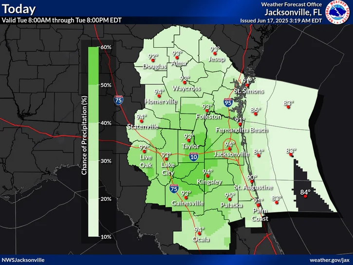
Today
A 40 percent chance of showers and thunderstorms, mainly after 2pm. Mostly sunny, with a high near 93. Heat index values as high as 103. South wind 3 to 8 mph.
Tonight
A 30 percent chance of showers and thunderstorms, mainly before 8pm. Partly cloudy, with a low around 76. Southeast wind 6 to 9 mph.
Wednesday
A 30 percent chance of showers and thunderstorms, mainly after 4pm. Mostly sunny, with a high near 94. Heat index values as high as 102. South wind 6 to 8 mph.
Wednesday Night
A 30 percent chance of showers and thunderstorms, mainly before 7pm. Partly cloudy, with a low around 76. South wind 6 to 10 mph, with gusts as high as 16 mph.
Juneteenth
A 40 percent chance of showers and thunderstorms after 2pm. Mostly sunny, with a high near 94. Southwest wind 3 to 7 mph.
Thursday Night
A 30 percent chance of showers and thunderstorms before 2am. Mostly cloudy, with a low around 76.
Friday
Showers and thunderstorms likely, mainly after 2pm. Partly sunny, with a high near 93. Chance of precipitation is 60%.
Friday Night
Showers and thunderstorms likely, mainly before 8pm. Mostly cloudy, with a low around 76. Chance of precipitation is 60%.
Copyright 2023-2025 FloridaWord.com


