Weather Severe Thunderstorm, Strong Winds, Heavy Rain Risk For Central Florida
National Weather Service Storm Prediction Center Severe Weather Forecast for Florida Sunday, May 11, 2025.
ORLANDO, Florida – Central Florida braces for a stormy afternoon and evening on Sunday, May 11, 2025, with severe weather threats, according to the National Weather Service in Melbourne.
Severe Weather Outlook
 National Weather Service Melbourne Severe Weather Forecast for Central Florida Sunday May 11, 2025.
 Isolated strong to severe thunderstorms will be possible once again this afternoon into this evening, mainly between 4 PM to 9 PM.
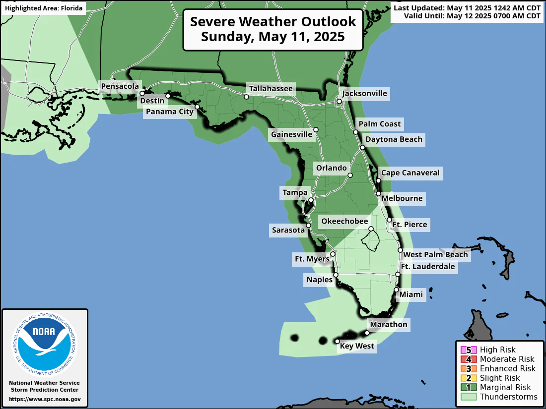
The National Weather Service Storm Prediction Center has issued a severe storm Outlook for May 11, 2025:
- Level 1 (Marginal Risk): Across most of Central Florida from Daytona to Orlando to Tampa.
- Potential Hazards: Gusty winds (55-65 mph), hail up to 1 inch in diameter, frequent lightning, and heavy rainfall.
What Damage Can Large Hail Do?
Hailstones the size of quarters or larger can:
- Dent vehicles and damage roofs.
- Shatter windows.
- Pose deadly risks to animals and people.
Hail can fall at speeds exceeding 100 mph, amplifying its destructive potential. Learn more about hail dangers here.
Extended Severe Weather Forecast for Central Florida
National Weather Service Melbourne Extended Severe Weather Forecast for Central Florida May 11-13, 2025. Sunday
- Rain: 30-70% chance
- A Marginal Risk (1/5) of severe weather north of the Treasure Coast
- Main threats: wind gusts up to 60 mph, coin-size hail, and locally heavy downpours
- Breezy along the coast
Monday
- Rain: 80% chance
- Widespread coverage of showers and storms throughout the day
- A Slight Risk (2/5) of excessive rainfall, increasing flooding threats
- Threat for strong to severe wind gusts, small hail, and brief tornadoes
Tuesday
- Rain: 30-60% chance
- Scattered to numerous showers and storms, lingering into the evening
- Rain chances diminishing by the evening
- A warming trend begins
Rainfall Totals Through Tuesday: 2-3 inches, with locally higher amounts up to 5 inches possible.
Contact Us Privacy Policy
Copyright 2023-2025 FloridaWord.com

