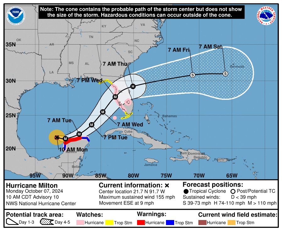
TAMPA, Florida – NOAA‘s National Hurricane Center in Miami, Florida, issued a Public Advisory at 11 a.m. Eastern Daylight Time on Monday, October 7, 2024, due to the presence of Category 4 Hurricane Milton over the Gulf of Mexico that is forecast to strengthen into a deadly Category 5 hurricane before making landfall on the west coast of Florida.
Hurricane Milton (formerly Invest 92L and Tropical Depression 14) is located about 720 miles southwest of Tampa, Florida, and is moving to the east-southeast at 9 mph (15 km/h).
NHC forecasters say that an eastward to east-southeastward motion is forecast through tonight, followed by a turn toward the east and northeast on Tuesday and Wednesday.
On the official NHC forecast track, Milton is expected to move near or just north of the Yucatan Peninsula today and Tuesday, then cross the eastern Gulf of Mexico and approach the west coast of the Florida Peninsula by Wednesday.
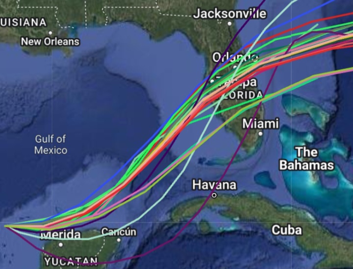
Computer models, often referred to as spaghetti models, are in good agreement during the first 24 hours that Hurricane Milton will move in a general eastward direction, then east-northeastward direction toward the Florida peninsula. Both the GFS (American model) and the ECMWF (European model) show a similar track.
However, there remains significant differences in both the location and timing of landfall. The UKMET (UK model) is fastest and farthest to the east, the GFS is slower and much farther north, and the CMC (Canadian model) is the slowest and keeping the storm offshore more than 24 hours longer than the other models.
The new official NHC forecast track calls for the center to reach the Florida west coast between 60-72 hours in a consensus of the latest GFS, ECMWF and regional hurricane models.
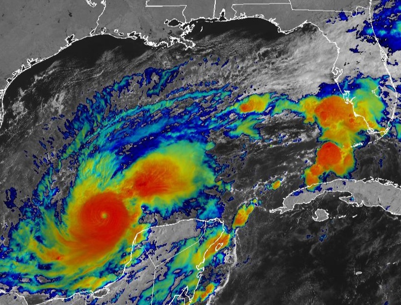
Data from a NOAA and U.S. Air Force Reserve Hurricane Hunter aircraft indicate that Milton is a major Category 4 hurricane on the Saffir-Simpson Hurricane Wind Scale. with maximum sustained winds of 155 mph (255 km/h), with higher gusts.
Milton is forecast to become a Category 5 hurricane later today and become a large hurricane over the eastern Gulf of Mexico.
Hurricane-force winds extend outward up to 30 miles (45 km) from the center of the tropical cyclone and tropical-storm-force winds extend outward up to 80 miles (130 km) from the center.
A Hurricane Warning is in effect from Celestun to Rio Lagartos.
A Hurricane Watch has been issued from Rio Lagartos to Cabo Catoche, from Campeche to the south of Celestun, and along the Florida Gulf coast from Chokoloskee to the mouth of the Suwannee River, including Tampa Bay and the Dry Tortugas.
A Storm Surge Watch is in effect for the Florida Gulf coast, from Flamingo northward to the mouth of the Suwannee River, including Charlotte Harbor and Tampa Bay.
A Tropical Storm Warning has been issued from Rio Lagartos to Cancun and from Campeche to south of Celestun.
A Tropical Storm Watch is in effect for the Florida Gulf coast from Flamingo to the south of Chokoloskee, north of the Suwannee River to Indian Pass, and the Lower, Middle, and Upper Florida Keys, including Florida Bay.
NOAA and Colorado State University forecast an “extremely active” 2024 Atlantic Hurricane Season, which runs from June 1 through November 30.
| NOAA historical hurricane data. Peak season and storm frequency. |
Peak hurricane season is September 10, according to NOAA and the National Weather Service‘s historical hurricane activity data.
Copyright 2023-2025 FloridaWord.com