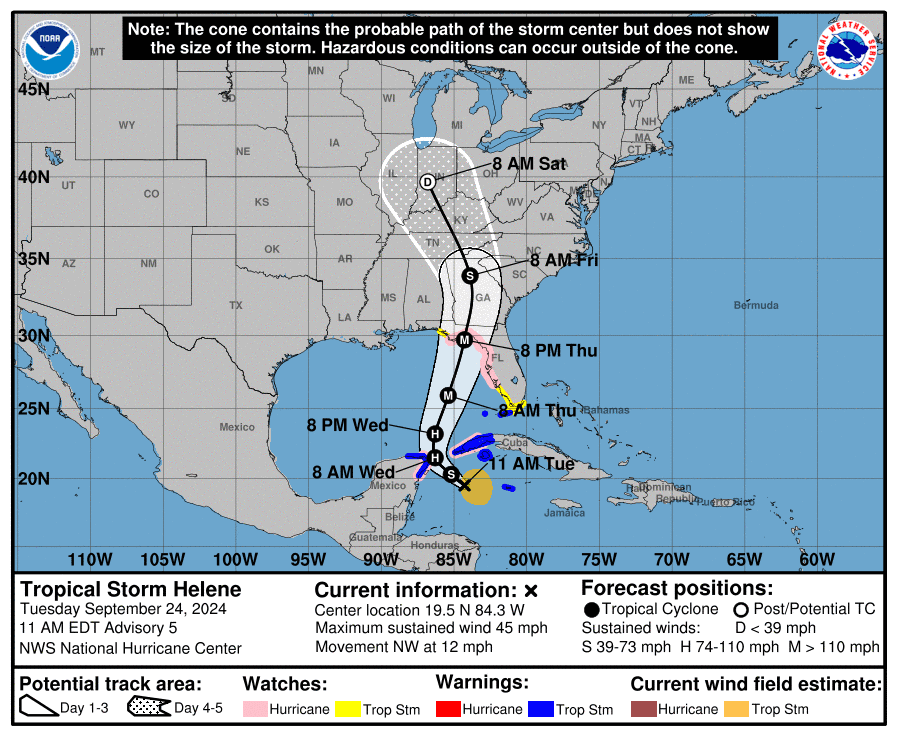
MIAMI, Florida – NOAA‘s National Hurricane Center issued a Public Advisory at 11 a.m. Eastern Daylight Time on Tuesday, September 24, 2024, due to the presence of Tropical Storm Helene, which is forecast to strengthen into Category 3 Hurricane Helene before making landfall on the Gulf Coast of Florida.
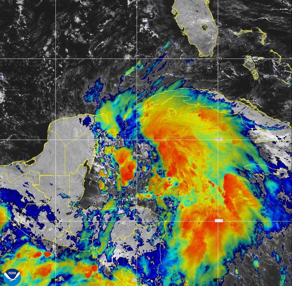
Tropical Storm Helene (formerly Invest 97L and Potential Tropical Cyclone 9) is located about 180 miles east-southeast of Cozumel, Mexico and is moving to the north-northwest at 13 mph (19 km/h).
NHC forecasters say that this general motion is expected to continue through early Wednesday. A northward to north-northeastward motion at a faster forward speed is expected on Wednesday and Thursday.
On the official NHC forecast track, the center of Helene will move across the far northwestern Caribbean Sea through tonight, and then move across the eastern Gulf of Mexico Wednesday and Thursday, potentially reaching the Gulf coast of Florida late Thursday.
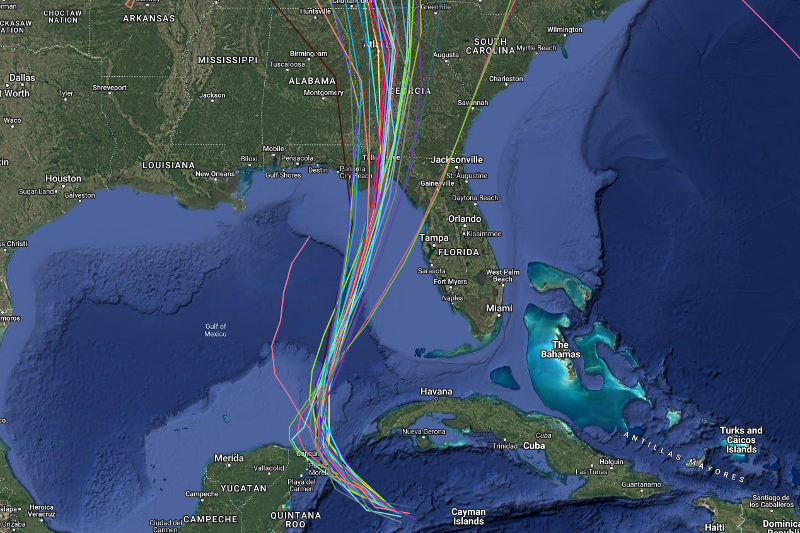
Computer models, often referred to as spaghetti models, are in strong agreement during the first 72 hours that Potential Tropical Cyclone 9 will move in a general northwest direction today, then a northward direction between the Yucatán Peninsula and the western tip of Cuba on Wednesday, before shifting in a north-northeast direction toward the Florida Big Bend area on Thursday. Both the GFS (American model) and the ECMWF (European model) show a similar S-shaped track.
There remains a very consistent set of models, and very little overall change was made to the official NHC forecast track update.
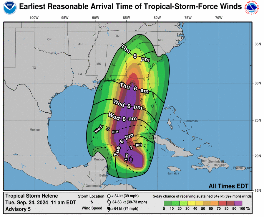
Data from a U.S. Air Force Reserve Hurricane Hunter aircraft indicate that Tropical Storm Helene has acquired a well-defined center of circulation, and maximum sustained winds have increased to near 45 mph (75 km/h), with higher gusts.
Tropical-storm-force winds extend outward up to 140 miles (220 km) to the east of the center of the tropical cyclone.
Strengthening is expected during the next few days, and the system is forecast to become a hurricane on Wednesday and continue strengthening into a Category 3 hurricane on the Saffir-Simpson Hurricane Wind Scale as it moves across the eastern Gulf of Mexico.
A Storm Surge Watch is currently in effect for areas from Indian Pass southward to Flamingo, including Tampa Bay and Charlotte Harbor.
A Hurricane Watch has been issued for Cabo Catoche to Tulum, Mexico, the Cuban province of Pinar del Rio, and for the U.S. coast from Englewood to Indian Pass, including Tampa Bay.
A Tropical Storm Warning is in effect for the Dry Tortugas, Lower Florida Keys west of the Seven Mile Bridge, Grand Cayman, Rio Lagartos to Tulum, Mexico, Cuban provinces of Artemisa, Pinar del Rio, and the Isle of Youth.
A Tropical Storm Watch is in effect for the Middle Florida Keys from the Seven Mile Bridge to the Channel 5 Bridge, Flamingo to south of Englewood, West of Indian Pass to Walton Bay County line.
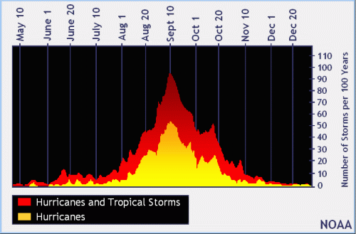
NOAA and Colorado State University forecast an “extremely active” 2024 Atlantic Hurricane Season, which runs from June 1 through November 30.
| NOAA historical hurricane data. Peak season and storm frequency. |
Peak hurricane season is September 10, according to NOAA and the National Weather Service’s historical hurricane activity data.
Copyright 2023-2025 FloridaWord.com