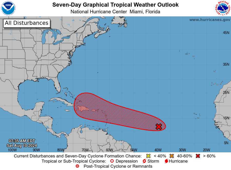
MIAMI, Florida – NOAA‘s National Hurricane Center in Miami, Florida, issued a Tropical Weather Outlook at 8 a.m. Eastern Daylight Time on Saturday, August 10, 2024, due to the presence of a system that may form into a tropical cyclone within the next 7 days over the Caribbean and then move near Florida.
The system (marked with a red “X”) is a tropical a tropical wave producing an area of showers located roughly midway between the Cabo Verde Islands and the Lesser Antilles that has become better organized since yesterday.
NHC forecasters say that gradual development of this system is possible during the next couple of days while it moves westward to west-northwestward across the central tropical Atlantic.
Afterwards, conditions are expected to become more conducive for development, and a tropical depression is likely to form by the early to middle part of next week while the system approaches and then moves near or over the Lesser Antilles.
The system is forecast to continue moving generally west-northwestward and could approach portions of the Greater Antilles by the middle to latter part of next week.
This system has an 80% chance of tropical cyclone formation within the next 7 days and a 30% chance within the next 48 hours.
If this system develops into a tropical storm or hurricane, the next name on the 2024 Atlantic Hurricane List is Ernesto.
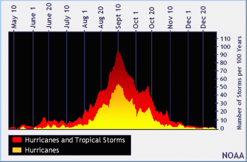
| NOAA historical hurricane data. Peak season and storm frequency. |
Although peak hurricane season isn’t until September 10, the beginning of August is when tropical storm and hurricane activity begins to pick up, according to NOAA and the National Weather Service‘s historical hurricane activity data.
NOAA and Colorado State University forecast an “extremely active” 2024 Atlantic Hurricane Season, which runs from June 1 through November 30.
Copyright 2023-2025 FloridaWord.com