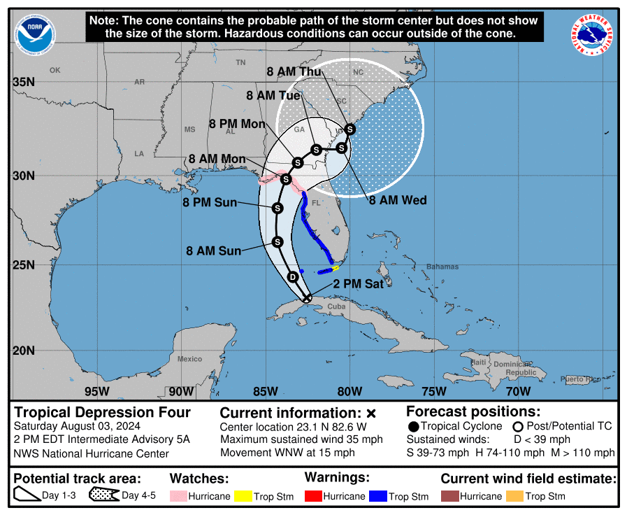
TAMPA, Florida – NOAA‘s National Hurricane Center issued a Public Advisory at 2 p.m. Eastern Daylight Time on Saturday, August 3, 2024, due to the presence of Tropical Depression 4, which is tracking toward the Gulf Coast of Florida.
Tropical Depression 4 (formerly Invest 97L) is located 115 miles south-southwest of Key West, Florida, and is moving to the west-northwest at 15 mph (24 km/h).
NHC forecasters say that a turn toward the northwest is forecast today, followed by a northward motion on Sunday and then a slower northeastward motion Sunday night and Monday.
On the official NHC forecast track, the center of the depression will move across western Cuba this morning, and then move over the eastern Gulf of Mexico later today and Sunday, reaching the Florida Gulf coast late Sunday or Monday.
Tropical Depression 4 has maximum sustained winds of 35 mph (55 km/h), with higher gusts.
Slow strengthening is expected today and tonight, and the depression is expected to become a tropical storm tonight. A faster rate of strengthening is expected Sunday through Monday, and the system could be near hurricane strength when it reaches the Florida Gulf coast.
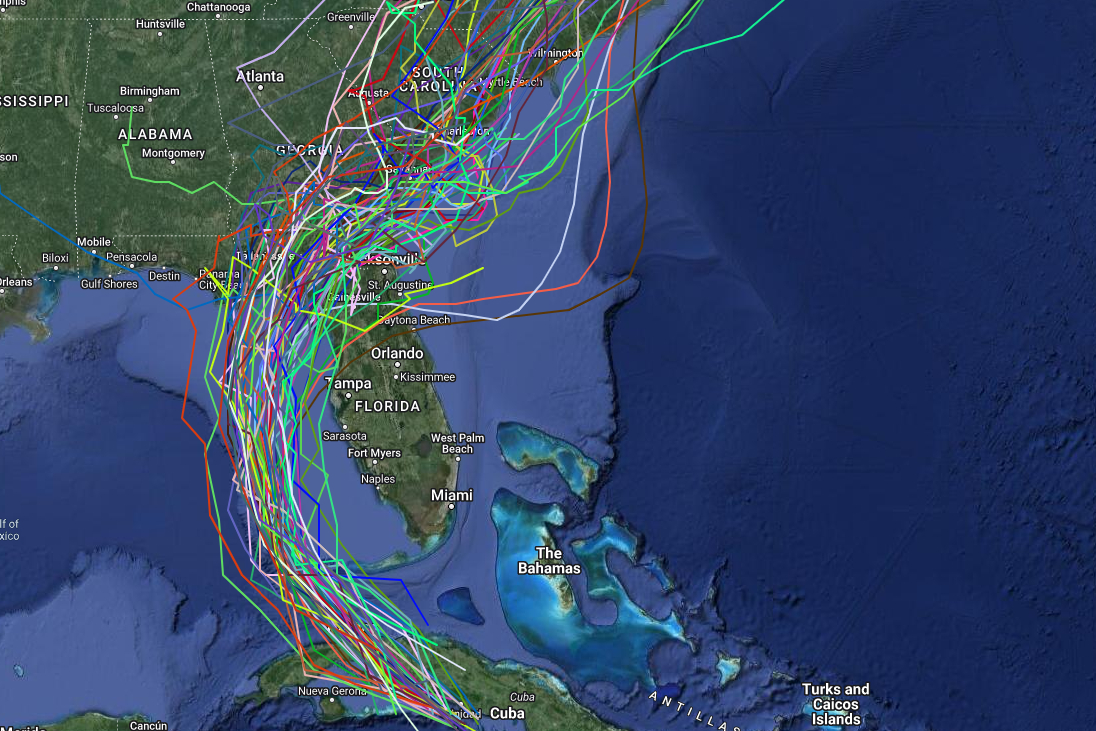
Computer models, often referred to as spaghetti models, are in general agreement that Tropical Depression 4 will move northwest near or over Key West, then hook to the north over the Gulf of Mexico and move parallel to the west coast of the Florida peninsula before turning to the north-northeast and making landfall somewhere between Tampa Bay and Panama City Beach.
The uncertainty in the NHC forecast increases significantly after 72 hours as the cyclone interacts with a portion of a U.S. trough.
The current GFS (American model) and ECMWF (European model) forecast the system to move into the Atlantic, and then turn back toward the southeastern U.S. coast by 120 hours.
However, the Canadian model moves the cyclone slowly northeastward across the southeastern states and does not bring it over the Atlantic.
This later portion of the new NHC forecast track shows a slower forward motion than the previous track due to changes in the GFS forecast since the previous advisory.
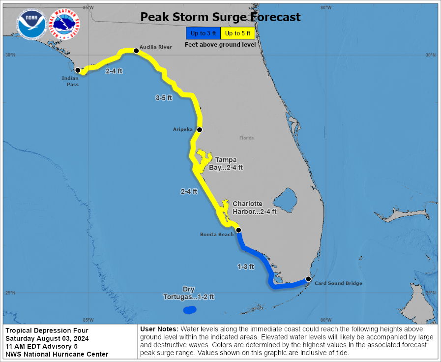
A Storm Surge Warning is in effect for the coast of Florida from Aripeka to the mouth of the Aucilla River.
A Storm Surge Warning means there is a danger of life-threatening inundation, from rising water moving inland from the coastline, during the next 36 hours in the indicated locations.
A Storm Surge Watch is now in effect for the coast of Florida west of the mouth of the Aucilla River to Indian Pass.
A Storm Surge Watch means there is a possibility of life-threatening inundation, from rising water moving inland from the coastline, in the indicated locations during the next 48 hours.
A Hurricane Watch is in effect for the Florida coast west of the Aucilla River to Indian Pass.
A Hurricane Watch means that hurricane conditions are possible within the watch area. A watch is typically issued 48 hours before the anticipated first occurrence of tropical-storm-force winds, conditions that make outside preparations difficult or dangerous.
A Tropical Storm Warning is in effect for the west coast of the Florida peninsula from from south of Yankeetown to East Cape Sable, and for the Florida Keys west of the Seven Mile Bridge including the Dry Tortugas.
A Tropical Storm Warning means that tropical storm conditions are expected somewhere within the warning area within 36 hours.
A Tropical Storm Watch is in effect for the Florida Keys south of the Channel 5 Bridge; and west of the Aucilla River to the Ochlockonee River.
A Tropical Storm Watch means that tropical storm conditions are possible within the watch area, generally within 48 hours.
Interests elsewhere in Florida and the southeastern coast of the United States should monitor the progress of this system. Additional warnings and watches will likely be required for a portion of this area later today.
If this system develops into a tropical storm or hurricane, the next name on the 2024 Atlantic Hurricane List is Debby.
NOAA and Colorado State University forecast an “extremely active” 2024 Atlantic Hurricane Season, which runs from June 1 through November 30.
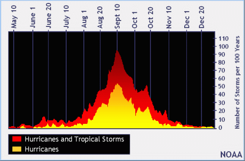
| NOAA historical hurricane data. Peak season and storm frequency. |
Although peak hurricane season isn’t until September 10, the end of July is when tropical storm and hurricane activity begins to pick up, according to NOAA and the National Weather Service’s historical hurricane activity data.
Copyright 2023-2025 FloridaWord.com