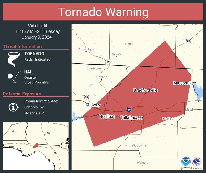
TALLAHASSEE, Florida – The National Weather Service in Tallahassee, Florida has issued a tornado warning for several counties in the Tallahassee, Florida area that will remain in effect until 11:15 AM. Eastern Standard Time.
The affected counties include southeastern Gadsden County, Leon County, southeastern Grady County in southwestern Georgia, and southwestern Thomas County in south-central Georgia.
At 10:43 AM EST, a severe thunderstorm with the potential for tornado formation was identified over Midway, moving northeast at 55 mph.
The primary hazards associated with this storm are tornadoes and quarter-sized hail, with radar indicating rotation.
The impact of this dangerous storm includes the potential for flying debris, posing a significant threat to those without proper shelter. Mobile homes are at an elevated risk of damage or destruction, and widespread damage to roofs, windows, vehicles, and trees is likely.
The dangerous storm is projected to reach Tallahassee and Tallahassee Community College around 10:50 AM EST.
Other locations at risk from this tornadic thunderstorm include Lake Bradford, Gaither Community Center, Tallahassee Memorial Hosp, Walker Ford Community Center, Rocky Hill, Miccosukee, South City, Griffin Heights, Tallahassee Regional A/P, and Governors Square Mall.
Emergency officials strongly advise residents in the warned areas to take cover immediately. Move to a basement or an interior room on the lowest floor of a sturdy building, and avoid windows. If outdoors, in a mobile home, or in a vehicle, seek the closest substantial shelter and protect yourself from flying debris.
This cluster of thunderstorms is capable of producing tornadoes and widespread significant wind damage. Residents are cautioned not to wait to see or hear the tornado and are urged to move to an interior room on the lowest floor of a building for their protection.
The coordinates of the storm’s path are identified as latitude 3047 and longitude 8404, moving at a speed of 47 knots at 243 degrees. The tornado is radar-indicated, and the maximum hail size associated with this storm is reported to be 1.00 inch.
Residents are urged to stay tuned to local weather updates for the latest information on this rapidly evolving and dangerous weather situation. The warning is issued by the National Weather Service in Tallahassee, and further updates will be provided as the situation develops.
Copyright 2023-2025 FloridaWord.com


